Mapping America: 500 Years of Cartographic Depictions
Maps and Atlases Relating to America in the Vassar College Library
By Ronald D. Patkus
Associate Director of the Library for Special Collections
Five hundred years ago, the German cartographer Martin Waldseemüller (1470-1521?) published an introduction to cosmography (the study of the universe) titled Cosmographiae Introductio.1 This work was accompanied by a globe and wall map, Universalis Cosmographia Secundum Ptholomaei Traditionem et Americi Vespucii Aliorumque Lustrationes. The 1507 map is a remarkable source, for it represents a European view of the earth in the years immediately following the first explorations of the New World. But it is especially valued for a more precise reason: it is considered to be the first map to use the word “America” to describe the New World. The term appears in the lower left panel of the map, and pays homage to the famous Italian explorer Amerigo Vespucci.2 Waldseemüller later published an atlas which used “Terra Incognita”—literally, unknown land—instead of “America,” but despite this apparent retraction, use of the term “America” spread.
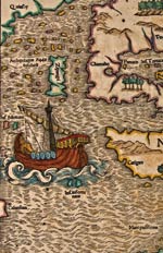
The 500th anniversary of Waldseemüller’s 1507 map offers an opportunity for us to consider the entire history of the mapping of America. During the 16th century the great cartographers Gerhard Mercator and Abraham Ortelius made significant contributions: Mercator’s map of 1538 is the first to distinguish between North and South America, and Ortelius’ 1570 map of the Americas was the first to appear in a modern atlas. During the 17th century, the “Golden Age” of Dutch mapmaking, many beautiful maps were produced in Amsterdam and elsewhere. Examples by Willem Blaeu, Nicolaas Visscher, and Johannes Jansson are among the most famous from this period. In the 18th century we see an ongoing development of topographical knowledge of America, as well as the emergence of maps by both Europeans and Americans which try to deal with political boundaries and other questions. These trends continue in the 19th century, as the American West is settled. During the 20th and 21st centuries, one takes special note of a variety of new technologies that have been used to produce maps of America.3
The study of the mapping of America is greatly dependent on the availability of original examples. 1,000 copies of Waldseemüller’s map are thought to have been printed, but today, only one copy of this world treasure is known to be in existence. This sobering fact reminds us of the vicissitudes of life and the fragility of our cultural heritage. At the same time, there is a certain comfort in knowing that the one surviving copy now rests in the Library of Congress, the nation’s largest repository of maps, in Washington, DC. We trust that the library will preserve this icon of Americana for years to come.4
Of course many other maps besides Waldseemüller’s enhance our understanding of the history of cartography. Working with private individuals and map dealers, libraries and cultural institutions have long been building cartographic collections. The most recent guide to map collections in the United States lists well over 500 institutions that have over 1,000 maps, or are significant in some other way.5 Some of these libraries concentrate on contemporary maps and automated cartography, some on rare maps and atlases, and others give attention to both areas. In recent years many libraries, library associations, librarians, and others have developed online resources in an effort to make information on historical maps more widely available.6
Like other colleges and universities in the United States, Vassar College maintains a collection of atlases and maps in its library. The holdings here do not have the breadth or depth of collections in larger institutions. Still, the holdings are impressive, and there are many highlights which greatly benefit students, faculty, and others interested in mapmaking and the history of cartography.
Vassar’s holdings in the area of maps and atlases are anchored by a wonderful Rare Atlas and Map Collection in the library’s Department of Archives & Special Collections. The cornerstone of this collection was laid in 1937, when Loula Lasker ’09 donated materials gathered by her brother, Edward Lasker. The Lasker Collection consists of twelve rare atlases, three portfolios of maps, and one early twentieth century volume on maps. Among the rare atlases Vassar received through this gift are significant 16th and 17th century works, including two 16th century editions of Abraham Ortelius, a 1634 Atlas Minor by Gerard Mercator (known for “Mercator’s projection”), and a beautiful copy of Willem Blaeu’s 1645 Theatrum Orbis Terrarum. Another bound volume contains many 18th century maps issued by the Nurnberg cartographer Johann Baptist Homann and his heirs. There are also several atlases which represent the efforts of 18th century British mapmakers, such as Henry Popple’s A Map of the British Empire, Thomas Kitchen’s A General Atlas and Thomas Jefferys’ An American Atlas. The portfolios each contain significant early maps of Europe, the Americas, and other parts of the world. Though America is not the only focus of the Lasker Collection, it is a highlight, providing us with many interesting and changing views of this part of the world, from the 16th through the 19th centuries.7
Forty years after the acquisition of the Lasker Collection, another important cartographic collection came to the college. In 1977, the library received books, maps, charts, and related materials from Jocelyn Harrington Breed, ’36. The Breed donation significantly enlarged the library’s holdings relating to cartography. The largest group of materials is made up of maps, most of which date from the 18th century, though examples from the 16th through the 19th centuries are present. All parts of the world are represented, but there is a focus on Europe. There are also a number of interesting maps of the Americas, some showing the entire continent, and others focusing in on particular regions or states. Of special note among the maps dealing with America are Justus Danckerts’ Novissima et Accuratissima Totius Americae (1688), Herman Moll’s A New Map of Ye North Parts of America (1730), and Robert de Vaugondy’s Carte des Parties Nord et Ouest de L’Amerique (1772). There are also several maps from the 19th century which give changing views of the United States, and the West in particular.
The tradition of alumnae donations of map collections has been continued in more recent times. In 2004, the Richmond John Rathbone Collection of Rare Maps was given to the library by Mary Rathbone Acker, ’56. This collection, though smaller than the Lasker and Breed collections, features several important 16th, 17th, and 18th century maps, including Sebastian Munster’s map of the Western Hemisphere (1552?), Nicolaas Visscher’s Novissima et Accuratissima Totius Americae (1680), and Matthew Seutter’s Diversi Globi Terr-Aquei (1720). There are also four maps in the collection by Samuel Lewis, who drew the official maps of the Lewis and Clark expedition. These maps all date from the 1790s, and focus on individual states, including New York, Massachusetts, and Pennsylvania.
Vassar’s Main Library also has noteworthy map collections. There is a large collection of topographical maps produced by the United States Geological Survey. The Survey was given responsibility for mapping the country in 1879, and thousands of maps have been produced since that time. The most famous maps are the 1:24,000-scale topographic maps, also known as 7.5-minute quadrangles. Vassar’s collection includes over 10,000 examples of these topographic maps, arranged by state, and dating from the 1930s to the present.8
Another Main Library resource is a collection of Sanborn Fire Insurance Maps, which is available on microfilm. Between 1867 and 1950, the Sanborn Map Company produced over 700,000 large scale maps of American cities and towns to assist in fire evaluation. The result was a unique record of the urban history of the United States. Vassar owns sets of maps for California, Connecticut, the District of Columbia, Georgia, Massachusetts, Missouri, and New York.9
Of course there are a number of atlases and maps that have come to the library not as part of any pre-formed collection, but rather as individual items. Some of these items are housed in the Department of Archives & Special Collections, and others reside in the Main Library. Both locations have atlases that were acquired through bequests of alumnae and others associated with the college. There are also a number of books that were purchased by the library from particular funds. Some of these atlases are large folios, while others are smaller in size. Many of them provide facsimiles of significant maps.
The Main Library also provides access to many online versions of maps. Many historical maps, for instance, can be seen on one’s desktop via the Evans Digital Edition of Early American Imprints, 1639-1800. Users can search the Evans Digital Edition in a variety of ways, or browse relevant groupings, such as “maps.” Nearly two hundred 17th and 18th century online versions of maps are included here. The library catalog includes records that link users to other online sources for maps.
Moreover, it should be mentioned that in addition to these map holdings, Vassar also has supplementary resources to help in the study of cartography. The Main Library has many reference sources in its reference section, its stacks, and online, which can assist those doing research on a particular map or cartographer. Some unique titles are also available in Special Collections. Needless to say, all of these items add substantially to the library’s holdings on geography and cartography.
Viewed as a whole, the collection of atlases and maps that has been assembled by the library is a valuable resource that continues the Vassar tradition of learning by “going to the source.” Over the years these materials have been used by students and professors not only in Geography, but in a variety of scholarly disciplines. Regardless of approach, original materials such as these stimulate appreciation of historical artifacts in the mind of the beholder. What is more—and anyone who has examined maps with students in a classroom setting can readily attest to this—they are also able to suggest questions and encourage intellectual inquiry in unique ways.
The Vassar Library exhibit “Mapping America: 500 Years of Cartographic Depictions” celebrates the quincentenary of Martin Waldseemüller’s map by showcasing it (in facsimile) and other maps depicting America from later centuries. Relying on library holdings, its main goal is to trace the historical development of mapping America. This could not be done in a comprehensive fashion, of course; instead, a representative approach is taken.
As with any public exhibition, “Mapping America” early on presented certain design challenges. Perhaps the most immediate problem before us was the scope of the project. Would it include both North and South America? Would there be views of particular regions, in addition to views of entire continents? Another issue that we had to grapple with was which maps and which cartographers should be included to illustrate particular trends in cartography. Finally, there was the problem of the oversized nature of many of our maps; this meant that it would be difficult to place some originals in the available display cases. In response to these questions, we decided to include views of both North and South America, but to concentrate, particularly in more recent centuries, on North America. We have also highlighted continental views, though regional views are represented as well; it was felt that without regional views the story of mapping America would not be complete. A number of maps by famous cartographers are present in the exhibit, but we also included maps by lesser-known cartographers, or even maps where the cartographer was unknown, in order to suggest something of the variety of mapmaking. And we have tried, whenever possible, to include originals, though in some cases it was necessary to rely on facsimile reproductions.
There are a number of highlights in the exhibit. The first item is the facsimile of Waldseemüller’s map (with its very sketchy outline of the Americas) and the last, from 2006, is a view of North America from space. These two items serve as intriguing “bookends” for the changes that have taken place in cartography over 500 years. In between we see several key trends. The 16th century is represented by maps of the great cartographers Mercator and Ortelius, as well as Munster. A reproduction of a Blaeu map represents the “Golden Age of Mapmaking” in the 17th century, though other interesting examples from this century are also included, such as a 1677 map of New England claiming to be the first one cut there. Maps from the 18th century, for instance those by Moll and de Vaugondy, reflect the concern among European nations for political boundaries in North America. 19th century maps in the exhibit document the ongoing development of the West. 20th century maps are especially interesting in their demonstration of the use of new technologies in mapmaking.
A special aspect of “Mapping America” is that students—not only librarians—have played an important role in its creation. During the fall semester of the 2006-2007 academic year, students in Geology 220, “Cartography,” completed projects involving about half of the maps in the exhibit. The project required students to choose a map and then identify it, examine its technical features, and study its historical context. The students then gave presentations on their maps, and wrote short papers about them. They had emerged as “experts” on their maps, and as a result were well-prepared to create exhibit captions for their maps. This kind of intense study, leading to a real-world application, was both pedagogically effective and personally rewarding. It is a perfect example of what learning by “going to the source” is all about.10
As stated earlier, it is hoped that the “Mapping America” exhibit will provide an opportunity for members of the Vassar College community and others to examine changing views of one part of the world, and to learn about the wider contexts of these changes. Yet we are cognizant of the fact that, for reasons of space, many noteworthy items in Vassar’s collection could not be displayed at this time. We therefore encourage those with an interest to explore these additional holdings at their leisure, in the Main Library and in Special Collections, and indeed to look further, beyond this library, to learn more about the fascinating world of maps and mapmaking.